Access to online map tools to locate an address or to get directions to a specific location is commonplace. Power engineers benefit from such a tool to quickly locate a substation, a particular feeder, a street corner, or to pinpoint the address where a fault occurred.
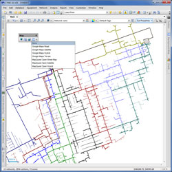
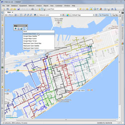
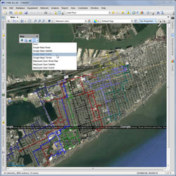
With the CYME Online Maps Service, you can now view the most commonly used online maps as a background map of your georeferenced distribution system model.
The CYME Online Maps Service provides the capability to view your electrical network model over Google™ maps and MapQuest™ Open maps.
More specifically, the service allows you to use different map formats from popular online map providers, including:
- Google™ Road
- Google™ Satellite
- Google™ Hybrid
- Google™ Terrain
- MapQuest™ Open Street maps
- MapQuest™ Open Satellite
- MapQuest™ Open Hybrid
With this option, the user can locate equipment and devices on the one-line diagram using street addresses, X/Y coordinates or GPS coordinates. Additionally, the simulation results can be viewed just as if in a Google™ map view.
The Online Map Service can be used in conjunction with the CYME Geographic Overlay module to display online and offline maps simultaneously; allowing the engineer to view additional geographic information more specific to the utility as multiple layers. This includes the network connection information, assets, resources, etc.; but also land register, rights of way, hydrography, topography, land cover, land use, population density, etc.
The functionality of both components is accessed through a comprehensive background map control tab in the CYME software.